Leeham News and Analysis
There's more to real news than a news release.

 Leeham News and Analysis
- Boeing defends 787, 777 against whistleblower charges April 17, 2024
- Dissecting Boeing CEO’s statement next new airplane will cost $50bn April 15, 2024
- Bjorn’s Corner: New engine development. Part 3. Propulsive efficiency April 12, 2024
- A350-1000 or 777-9? Part 2 April 11, 2024
- Pontifications: Boeing “transparency”–not so much. April 9, 2024
Bjorn’s Corner: Landing after navigation, Part 2

By Bjorn Fehrm
13 May 2016, © Leeham Co: Last week we started to describe what is necessary to make a precision approach after a flight. We described the rather elaborate installations needed for the classical precision approach with an ILS system. It requires two transmitters and large antennae installations for each runway.
We will now describe the system which will replace ILS as worldwide instrument landing system, an augmented Global Navigation Satellite System (GNSS), where GPS is the variant provided by the US Department of Defence, Figure 1. Other GNSS are Russia’s GLONASS and Europe’s Galilleo.
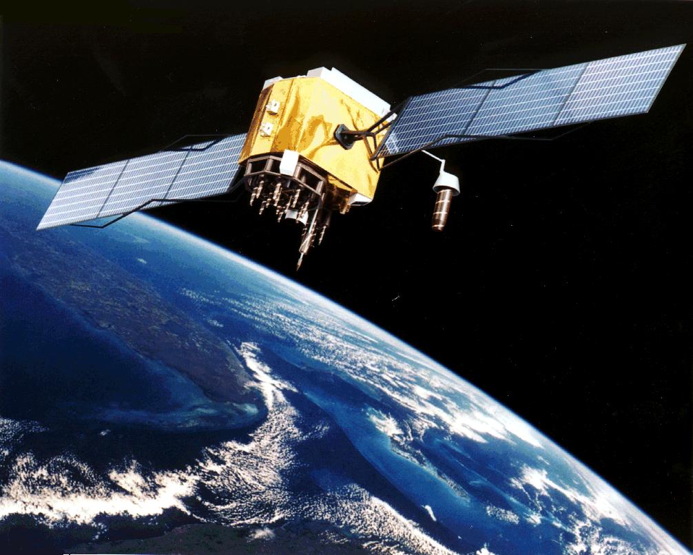
Figure 1. The GPS system consists of up to 24 satellites which deliver position, velocity and time. Source: Wikipedia.
The problem with a non-augmented GPS is the precision. Classically the accuracy was worst case any where in the World around 100m horizontally and 150m vertically, but that was when the US military deliberately reduced the accuracy for civil use (Selective Availability). Today this deliberate reduction has stopped and the accuracy is 25m horizontally and 43m vertically worst case.
This is not enough for a precision approach. We will now describe what is done to bring the accuracy to a level where precision approaches can be flown with GPS.
Augmented GPS
A GPS position fix by a receiver can be made more accurate if the GPS signal contains good correction information for the different atmospheric disturbances the signal can endure. The way to provide this information is straight forward. One puts up a fixed GPS receiver at a known location and observes what the GPS signal says for that location. The difference between the true location and what is given by the GPS is the correction.
There are principally two ways to measure and deliver this correction:
- Deploy a wide area system which covers a continent and which injects its corrections in the GPS signal, therefore not requiring any additional receiver capabilities other than processing the correction. The accuracy of such a system will be good enough for ILS Category I in the covered area, the most common ILS with minimum of around 200ft above the runway threshold.
- Set up a local system at an airport which covers the precision approaches for the airport. The accuracy of such a system will be good enough for ILS category III approaches, the most exact ILS with minimum down to 50ft.
Wide area augmented GPS
The wide area augmented GPS for the North American continent is called WAAS (Wide Area Augmented System). It uses 38 fixed position receivers placed over the continent to collect GPS accuracy data and then sends these corrections to the satellites. The WAAS correction can be received with GPS receivers that need the accuracy such as aeronautical receivers. All modern aeronautical GPS receivers can handle WAAS signals as well as the more exact local correction, see below.
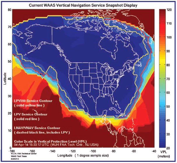
Figure 2. WAAS coverage of North America. Source: Wikipedia.
Figure 2 shows the coverage of the WAAS . The yellow line puts the border for ILS Cat I accuracy which requires minimum 16m laterally and 4m vertically. The WAAS performance in this area is better than what is required for the ILS Cat 1 system.
The WAAS system also provides the Integrity (warning for bad signals) and surveys the Availability required for the precision approaches. WAAS means an approved GPS receiver can provide precision approaches with “Localiser Performance with Vertical Guidance” to 200ft minimum (LPV200) over the whole of North America.
It’s pretty impressive that with no ground-based equipment, LPV procedures can be made and published for this area. To get to the lowest minimum, which is around 200ft, the runway must have adequate approach lighting and a parallel taxiway but no other installation will be necessary at the airports.
For simpler airports, less demanding procedures with higher minimums can be published (LP, LNAV/VNAV..)
Further, WAAS also improves the accuracy and check integrity and availability for the underway GPS-based RNAV, allowing tighter routing with lower minimums.
Over 3,500 WAAS-based approaches (LPV, LP, LNAV/VNAV) have been approved and published in the area during 2015, serving over 1,700 airports. LPV approaches now outnumber the ILS systems in this area. Europe (EGNOS) and Asia (India GAGAN, Japan MSAS) have also implemented wide area augmentation systems.
Local augmentation systems
The local augmentation systems are called Ground Based Augmentation Systems, GBAS. Here the correction and integrity/availability checks are valid for an airport. Figure 3 shows a system which has three GPS receivers and a VHF transmitter to send the correction signals as a broadcast data-link message to the VHF COM receiver of the aircraft.
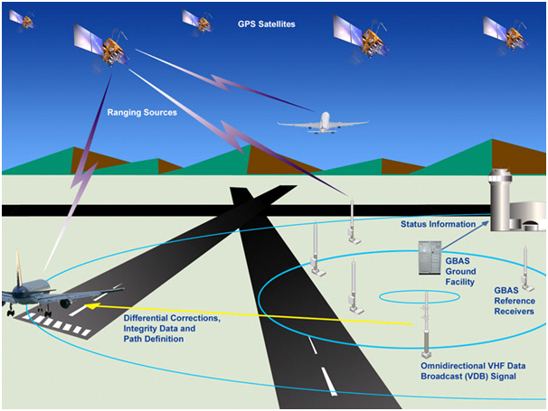
Figure 2. Principle for Ground Based Augmentation Service, GBAS. Source: Wikipedia.
The GBAS correction requires certain ground based equipment and a COMs receiver in the aircraft that can decode the GBAS corrections. But this is nothing in terms of installations compared to ILS. Imagine an airport like Nice with two runways and four approaches. Instead of four complete ILS installations, all to CAT IIIc standard, you need 3 GPS receivers and an updated COMs transmitter in the tower.
Coverage for a GBAS is 20nm, well beyond what is needed for precision approaches with the GBAS Landing System, GLS. GLS approaches are operational at Newark and Houston airports in the US; at Bremen, Frankfurt, Zurich, Malaga and Toulouse in Europe and several other airports around the world.
The GLS system is in its infancy but is spreading fast, both to airports and aircraft. The Airbus A350 that I piloted a year ago had GLS. One of my approaches at the Toulouse Airport was a GLS approach. The dialing in of the system was different to an ILS Cat III (channel number instead of frequency) but the actual flying experience was identical.
Summary
WAAS and GBAS will revolutionize aerial navigation. The only infrastructure needed for a World class underway and precision approach system will be one WAAS style installation per continent and GBAS installations for the airports which want to offer ILS CAT II and III level approaches. All other airports will be ILS CAT I level capable with no local system installations needed.
Hi Bjorn,
I am curious that when the Galileo system comes online (which is supposedly going to be more accurate than GPS) would it in conjunction with GPS allow for Cat III even without WAAS or GBAS being available?
For the ultimate in accuracy might a WAAS or GBAS be installed for Galileo as well as GPS allowing for redundancy as well as even greater accuracy?
Pretty amazing to think how far navigation has come in a few short decades!
There will be a wide area autgmentation system called EGNOS. Given the higher accuracy of the base satellites (said to be 1m but is this worst case in the coverage area?) a wide area augmented satellite signal could meet the accuracy criteria for GLS. But you need Integrity surveillance (is it OK) and Availability (low downtime) as well. Lets see what happens.
GPS is solid in all aspects, Galileo is not. But we can expect future avionics to be able to operate with both if the three factors can be brought to the spec needed, otherwise the aeronautical world will use GPS. Any joint use requires that Galileo capable receivers are there in the first place and that the three factors are present for the satellite and augmentation systems.
Intersting post as always, Bjorn.
I might add that there is also an European WAAS equivalent, called EGNOS. Which works with GPS (and Galileo in future).
Coverage map: http://gpsworld.com/wp-content/uploads/2014/12/Medusa_image002.png
Thanks, yes I did list it in the article.
Wide area augmentation is ingenious, enables a whole continent for really smart and useful procedures with minimal infrastructure.
Right now the US GPS is the GNSS that counts but there will be more choice going forward.
Interesting article, Bjorn, thanks.
Many years ago Boeing had a 737-900 hi-tech demonstrator showing GPS based approaches at Moses Lake. The flexibility offered by GPS for defining procedures is just amazing. The 737 demonstrator had many interesting features including an infra-red forward looking camera display on the HUD, advanced noise abatement, etc. We really liked it and were happy to see that Boeing focuses on improvements that add value.
More than 1,000 Boeing GLS-equipped aircraft are now in use and the number is increasing rapidly. I understand GLS is standard on some Boeing airplanes, optional on others.
Thanks Andy,
I knew the A350 I flew had GLS but not the status on more high volume production aircraft. Do you know the vendor for the 737 GLS, Collins or Honeywell?
Anyone knowing how other Boeing and Airbus models fare in such a comparison?
Guess it’s time to drill a bit in the operational readiness on the aircraft side. I saw that the private and Biz jet avionics vendors are well advanced with WAAS and GBAS capable avionics, looks good.
Back in 2006 the 737 had GLS made by Rockwell Collins. No idea what Boeing has now on the 737 or other models. As I recall, it worked well with autoland.
Small jets are more likely to land on small airports without ILS. On the other side there should be only a few airports where a 747 or A380 can land without ILS.
I would like to add that there was a LORAN system that did that during the GPS gap period.
I never flew it, bit I did get to do some 65 ft fishing vessel runs with it.
It was incredibly accurate, the owner would located a skate line with a click when he dropped the buoy, we returned to one of his sets, we saw the buoy before we got to it but ran the Loran as if we had not, we were within 50 ft of it when it said we were on that exact spot. Obscure corner of AK not intended as a prime Loran nav area.
He told me that using lat and long coordinates it did not do nearly that good, but if he pushed the “record this” button, it was spot on in bringing him that close (and in any weather that is more than close enough)
US built Loran stations across the US to allow use as an air navigations aid.
I don’t remember if they ever did precision approaches with it, but it worked well.
We ran a pre plotted safe course one night out of an Alaskan port, socked in, zero visibility, wind, rain. It took us right on track (we did cross check with Radar). We ran all night on it without a hiccup-.
Its still in existence and under discussion for backup from what I can find.
I continue to wonder if it would be a good idea to keep those as backup systems.
You have a natural backup to the GPS in the inertial NAV and VOR/DME, all managed by the FMS. I know LORAN was used for cross Pacific and Atlantic navigation for long range aircraft a long time ago but there are better methods which are aeronautic-ally certified today.
eLoran (a significantly updated version of Loran) is seen by some as a good backup to GPS. Doing eLoran ‘digitally’ makes a significant improvement to the ease of use, accuracy, etc.
There’s so much stuff now that stops working if GPS breaks (for whatever reason); train doors, mobile networks, shipping safety in the English channel, etc. Having a workable and cheap purely terrestrial GPS backup seems like a good idea.
I don’t think eLoran would be good enough for an aircraft wheels-on-the-tarmac landing aid, but it would get you close to the end of the runway. However it may as well be fitted as a useful navigation aid should eLoran actually get rolled out in a big way.
GNSS systems are too readily chosen for timing and position finding. It’s cheap and easy, but these are not the most important criteria denoting a “good” system.
GPS and GNSS in general has many disadvantages.
It is desperately easy to jam. Right now we’re getting worried about drones near airports. We don’t want to have to worry about whether anyone has a GPS jammer too.
The satellite system itself is operated in a “high reliability” way, not a “safety-critical” way. They’re not the same thing. See http://www.theregister.co.uk/2016/02/03/decommissioned_satellite_software_knocks_out_gps/ for an example.
It is vulnerable to being completely wiped out by a sun-burp, and can’t be quickly re-instated. Though admittedly if that ever happened we’d likely be having severe problems down here anyway, and flying somewhere would probably be the last thing on our minds.
There’s no particular problem with GNSS being used as one of several systems for operating an airliner. However human nature being what it is means that it will likely become the only thing that gets used for landing aircraft.
Mattew:
Thank you, my mind goes in similar vein.
Chinese have been testing a geosynchronous orbit attack option since 2013 I believe.
And while a lot stops if the Sun smacks us, a lot goes on that depends on good positions fixes and an ability to keep going would be a very good option.
I would think you could continue to navigate oceans ok (lots of spacing) but once you got near land a shift to e Loran would be a major help and maybe only way for long periods.
It seems to me that in this whiz bang age, Loran was slighted when it could have been the lead into the GPS and continued as back up. It certainly did not lack for one dimensional accuracy.
I get that, but they could have been doing this much sooner than GPS. I think it was a shame.
How it would work at Jet altitude and or cross ocean at those altitudes I don’t know, but it was deisnged for Ocean work orignlay of course.
US built Chain Stations across the US to allow at least light aircraft to use it back in the late 70s or early 80s.
It seems we could have had it much sooner and then a hand off to GPS if better and more reliable. All goes away if there is a war or course.
How fast a drift does inertial result in and you and can you still land with it (ie. what category) and or just sufficient for airway navigations?