Leeham News and Analysis
There's more to real news than a news release.


Bjorn’s Corner: We fly to Nice

By Bjorn Fehrm
22 April 2016, ©. Leeham Co: Last week we described the function of the aircraft’s Flight Management System, FMS. Now we will use the FMS to program a flight between Innsbruck in Austria and my hometown Nice on the French Riviera.
To make it practical and easy to follow, we will focus on how the Flightplan that we have programmed into the FMS will be processed. To follow that, we look at the display of the FMS navigation on the aircraft’s navigation display. There, one can follow how the FMS and Autopilot work through all the information that a flight-planned mission contains.
The cockpit we see in the picture is the aircraft we will use, an A319 that we have borrowed for the day from Lufthansa, just to help us understand how navigation with a FMS works. It is of course not a real aircraft, but it’s not far from it.
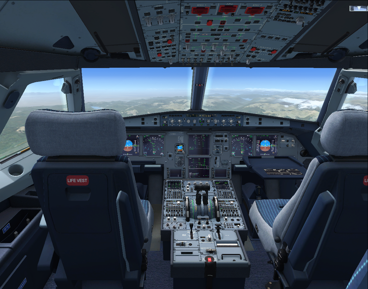
Figure 1. Our flight for the day, Aerosoft’s A319. Source: Aerosoft’s A319 flight simulator
The best flight simulators that are available for your PC today are extremely well done and realistic; this is one of them. It’s an A319 simulator from the German company Aerosoft. I flew the mission for us yesterday.
Let’s see how it works.
FMS managed flight from Innsbruck to Nice airport
Figure 2 shows the route we will follow to Nice. We start at Innsbruck Airport, LOWI, and follow a Standard Instrument Departure (SID) route to the navigation point INN (it is also a VOR navigation beacon). From there, we follow the airway UM726 to BZO, once again a VOR close to the Süd Tirol city Bozen. Then we follow another airway to EVANO and finally to BORDI, which is the navigation point for the seaside town Bordighera on the Italian Riviera.

Figure 2. Route for the mission, from Innsbruck to Nice. Source: Aerosoft manual. Click to see better.
From BORDI, we go out to sea to follow a Standard Arrival route (STAR) called BORD6C via the TRANsfer procedure NERAS, which takes us to an ILS landing on Nice runway 04 Left.
Figure 3 shows the Navigation Display (ND) after we have taken off at Innsbruck and are climbing up to our cruise altitude. The picture shows how the displays are arranged in the aircraft with the Primary Flight Display (PDF) to the left and the Navigation Display (ND) to the right. Above we can see the panel where one controls the ND (LS-VOR-Nav-Arc-Plan knob and range knob). To the right is part of the Autopilot controls and below a standby horizon and the Engines page on one of the central screens.
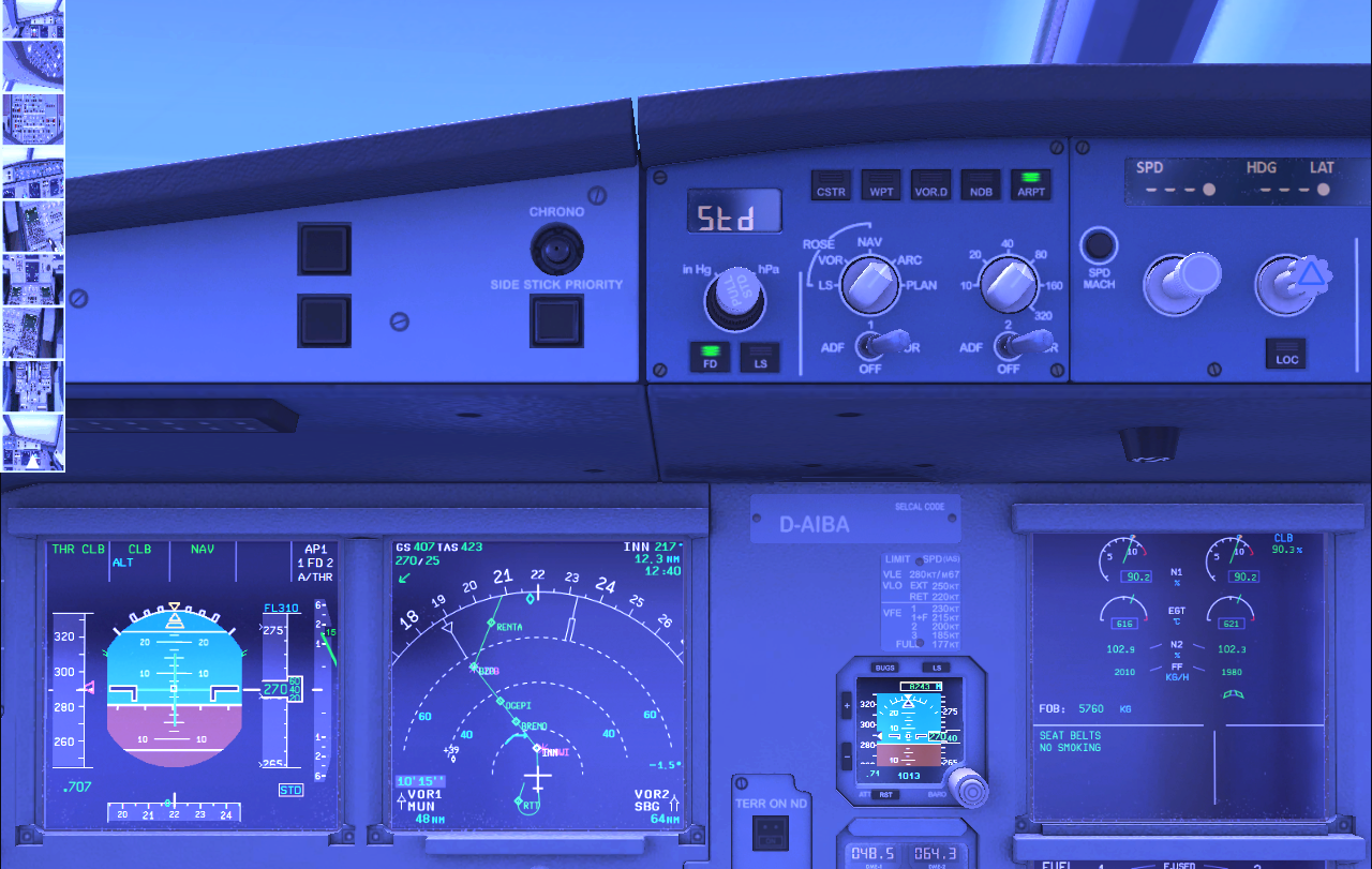
Figure 3. The Navigation Display surrounded by PDF (left), Standby Horizon (right) and ND controls (top). Source: Aerosoft A319 simulation. Click to see better.
On the ND (Navigation Display), we have just climbed straight ahead after take-off as Innsbruck is in a valley and we had to pass the NDB (Non Directional Beacon) RTT (Rattenburg) at minimum 9,500ft before we turned back to the INN (Innsbruck) VOR (white INN overlaid on the airport LOWI in Magenta). We now climb on our route to our initial Flight Level of 31,000ft (FL310).
In Figure 4 we are just about to reach cruise Flight Level 310. The blue cranked arrow shows where we will reach cruise FL just before BRENO (The Brenner pass).
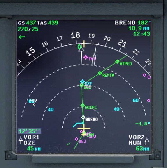
Figure 4. ND picture. We reach cruise altitude just before BRENO. Source: Aerosoft A319
Observe that I have the two VOR’s shown in the lower corners. One can see the bearing arrows in the display pointing to these VOR’s that the FMS use to check the Inertial Nav platforms that the aircraft has and below is the DME distance to these VOR. The VOR OZE is visible in light blue (means it is active, otherwise it would be magenta) just beyond our turn waypoint.
In Figure 5 we have reached the Italian Riviera and it’s time for descent, market with a white cranked down arrow. We have 21nm left to EVANO (upper right corner shows bearing, 323°, and distance to next waypoint and estimated overhead time) and the descent will begin just before BORDI. After BORDI starts our TRANsfer procedure NERAS out over the Mediterranean sea leading to our STAR (Standard Arrival Route) BORD6C. It has many waypoints (green) and altitude constrains (magenta circles), a bit busy in this range scale but will be better later on.

Figure 5. We will soon start descent before BORDI and then fly our Nice STAR. Source: Aerosoft A319
On the standby instrument we can see that we are at 31,000ft=9,448m and our indicated airspeed is just below 290kts. On the ND we have Ground Speed (GS) 429kts and True Air Speed (TAS) 449kts in the top left corner.
In Figure 6 we are turning left into our TRANsfer procedure. Here we are descending to 4000ft over sea level (QNH 2012mb not set yet on the standby horizon). We then have to stay there until we catch the glideslope of the ILS at the outer marker NI122. In the picture we can also see the backup VOR/DME display the aircraft has. Check the needles and distance; they are synced to the VOR needles one sees in the ND and the distances are the same. Its just a backup display of the information from the VOR/DME receivers.
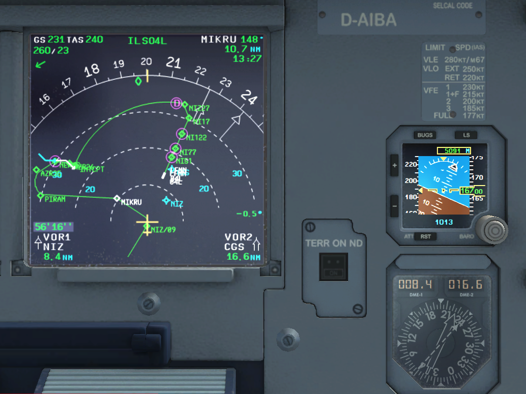
Figure 6. Entering our Nice TRANSfer procedure NERA. Source: Aerosoft A319
Finally in figure 7, we are just waiting to turn in to get established on the ILS inbound for Runway 04 left at Nice airport. The cranked arrow shows were we shall leave 4,000ft and follow the ILS at the outer marker NI122, over the middle market NI77 and inner market NI51. The landing I then made was OK, so we all arrived safely at Nice.
Hope you enjoyed the trip!

Figure 7. Waiting for right turn to ILS for RWY 04L on Nice airport. Source: Aerosoft A319
Welcome in France.
Hometown in Nice? I was thinking you were Swedish !
Enjoy the rivera (virtually) and do not forget that France has other very nice places (like the others countries for sure).
Thanks Frank.
I enjoy the Riviera both virtually and real, its real name is Cote d’Azur but the Italian “Riviera” name is so much nicer :).
Bjorn
Thanks, Bjorn, for this. Three quick questions. One, no problem (“for real”) for Lufthansa to fly the route– because the departure and arrival cities are both within the EU? Two, can you file “gps direct” from SID INN to STAR Nice? Three, 31,000 seems a little high for the distance. Could you file for 28,000, and does “the system” expect you to generally file “even thousands” westbound? Thanks again!
1) EU airport to EU airport flights can be flown by any EU based carrier.
2) In theory you could takeoff from your departure airport and fly a direct GPS track straight to the outermarker of your arrival airport, however this wouldn’t actually work for two reasons. Firstly, Innsbruck obviously has a lot of high terrain around it, meaning that an immediate turn towards Nice after takeoff would result in CFIT. Secondly, ATC’s Clearance Delivery would never approve a flight plan that was a direct track (Europe’s skies are unfortunately too crowded). In parts of the world where the skies are less congested, this might be allowed.
3) The altitude depends a lot on the aircraft’s weight. Bjorn didn’t mention his Zero Fuel Weight or his release fuel, but if the aircraft isn’t heavily loaded, an altitude of 31,000 isn’t unrealistic for a flight of that length. You are correct about westbound flights being in even flight levels.
Thanks, Ali. I did know you’d need to follow the SIDs and STARS, and maybe even get a little vectoring from ATC after the SID from INN, given the mountains surrounding it. I know this was just Bjorn’s FMS example, but I did note if you wanted to actually fly this route home tonight, you’d be on Austrian’s Q400 (DLH codeshare) to Frankfurt, then connecting to DLH to NCE. $515 one way, ouch. (Just like the good, old USA! No Ryanair impact apparently.) My thanks again.
Nice explanation, Bjorn. Your pieces are always a pleasure to read. Just a question about the STARs into Nice: would you happen to know why a lot of the STARS coming from the East into the 04 runways at Nice take you quite a way out over the Mediterranean? I’m just a little curious.
Hi Ali,
thanks for the other answers, wasn’t sure re the answers. Re east STARs for 04 at Nice. It is a busy airport, actually the third busiest in France after CGD and Orly. It got the Alps behind and the whole Mediterranean to buffer up and schedule the traffic with. I can see from my windows how the controllers slot in aircraft via radar vectoring into the wide arc that leads to 04 finals. Guess it is convenient to just have everyone enter this arc and just widen or shrink it when needed instead of putting flights in holding, easier for all.
Have been on some flights that go quite long into the Mediterranean before turning back, all due to traffic. Have yet to land there other than in simulation 🙂 .
Small typo: CGD is in China » CDG
Thanks for the very interesting articles all the time!
Semantically the phrase ‘Italian Riviera’ is redundant, as riviera is just Italian for coastline.
But certainly use the modifier German Riviera or Belgian Riviera for perhaps lesser coastlines
I always thought it was used to differentiate the “French Riviera”‘ from the “Italian Riviera”. (And Monaco’s in there somewhere too?)
The French have a different term, Cote D’Azure as shown here for the airport mentioned.
Aéroport Nice Côte d’Azur
Very nice Nice approach…
But that ILS 04 approach is very rare ( I’ve probably done it three or four times in the hundreds of flights I flew to NCE ). The reason is of course the noise that would disturb rather affluent people living in Antibes…etc… so, as a matter of fact one would really be allocated an* RNAV A* let-down if visibility is above 10 km, with an MDA of 2000 ft. Otherwise, it’s an *RNAV Z* with a DH of 250 ft.
Arrivals from the East of the airport are incredibly spectacular; they make Nice the most beautiful approach in the world.
Hi Pihero,
thanks for adding to the site. I can now also add the answers you gave to me via email for MontanaOsprey’s questions.
– You are not “filing” direct for safety reasons (lost radio) but most of the time ATC will give you a direct routing.
– FL310 is low for a normally loaded A319 flying Innsbruk-Nice, in real life it would be even higher, often up to FL390.
Bjorn
I got to visit the SFO approach center (Transcon?) one time.
Stunning to see hundreds of miles out aircraft getting lined up to land.
As Bjorn noted, you could see them vectoring onto a distant arch and then working their way into line with a Runway (parallel runways)
What did not seem like a lot of activity was 20 or 30 working their way into the landing slots. No sooner did one land and another showed up on the edge.
This was late at night, phew and its gotten nothing but more busy.
No need to visit the SFO approach centre, you can see it for the Oakland/Sanfrancisco area with the Webtrak flight tracking display
http://webtrak5.bksv.com/oak3