Leeham News and Analysis
There's more to real news than a news release.

Bjorn’s Corner: Largest navigation change since radar, Part 8
 August 03, 2018, ©. Leeham News: In seven articles we have discussed the largest change in how air navigation is done since the Second World War when Radar was invented.
It’s time to summarize the changes and what it will mean for how we fly in the future.

Figure 1. Airbus Vahana Air Taxi concept. Source: Airbus.
Going from approximate air navigation to exact
When changing from radar-based to ADS-B based separation we go from an approximate lateral position, say with +-100ft/30m, to a position we know is within +-5ft/1.5m.
The radar-based navigation is relying upon all participants keeping a certain altitude using their pressure sensors (Altimeters or Air Data Units). Faults in altitude sensor accuracy can accumulate to over +-50ft. This shall be compared with an ADS-B vertical accuracy of +-5ft.
Near-term changes
With this positioning accuracy, separation can reduce in different phases of flight. It means the NexGen ATC system in the US, based on ADS-B, can take more traffic in the same airspace.
Once we have satellite-based ADS-B receivers over the vast areas where there is no radar coverage today, we can change the way of flying these spaces. No more stale tracks, where the slowest aircraft dictate the speed. And where you can only enter and leave at certain points.
Air navigation can be done as it’s done for Radar covered areas today, increasing capacity and reducing fuel consumption.
Long-term implications
Accurate and dependable air navigation means we can develop new ways of controlling air traffic. With the position accuracy of ADS-B and ATC control commands/responses sent over data links, a cleverer way of air navigation is possible.
Most likely new air transport applications like Urban Air Taxis will use these possibilities first, Figure 1. But once proven they will gradually change the way air transport is done from A to B.
The vehicles will fly in an automated preprogrammed path, with the navigation function relying on the accuracy and dependability of ADS-B and of Datalink communication to control the path. Pilots will become more and more safety guardians, taking over in case of system problems.
The vehicles might be surveyed and back-up controlled from remote, like for the advanced drones used for military missions today, Figure 2.
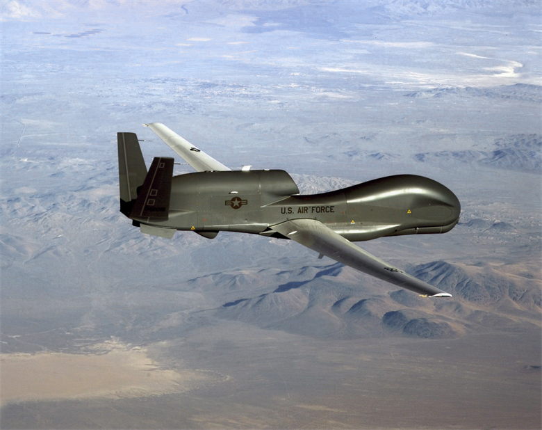
Figure 2. Global Hawk flying a remotely controlled mission. Source: Google images.
The Global Hawk is a candidate to qualify to fly in civil airspace, navigating with airliners in their airspace. If a vehicle flies automated and pilotless in airliner airspace, the step to change the way the other air transport vehicles are piloted in that airspace is small.
This is not attractive to a pilot like me, used to fly my own path and be part-time told what to do. But it’s the only way air transport can grow the transported volumes to the level we expected for the future.
How long will it take? A long time and the shift will be gradual. But we no longer control lifts manually nor do we have drivers in our airport shuttle trains.
I doubt we see pilotless airliners but we will have airliners operated automatically from Chocks off to Chocks on, with the Pilot(s) more as safety controllers than doing the flying.
And as we come to accept Drones mixing it in the airspace, the step to remotely controlled air transport is not far.
The accuracy and dependability of the new way of navigating and communicating will be necessary for such developments.
Hi Bjorn,
Excellent series. Learned a lot!
I just hope you are right and so we will never see pilotless airliners. I for one will not fly in an airplane without a human pilot. No matter how sophisticated our sensors, systems and computer codes that control everything are, nothing, repeat nothing, can replace a human brain in extraordinary situations that require some thinking and extrapolation from experience and knowledge. These things cannot be done correctly even with sophisticated AI, since you cannot pre-program every conceivable scenario and AI is only as good as the knowledge base it is based on.
And yet, drone strikes occur every day, with fewer and fewer apparent flying mishaps. And, let’s face it, with a massive, looming pilot shortage, the future’s eventually headed towards “Computer, fly us to Denver right now” type airliners—with maybe a safety pilot in tow (on board). First, it’ll be the freighters, then the airliners. It’s like the beginning of the manned flight age, all over again. (“Man is not meant to fly, blah, blah.” LOL)
All these drone strikes you are talking about are carried out by remotely piloted systems, with a human in the loop. The important parts of the drone flight are performed by pilots and not done automatically.
Give it five to ten years…the seeds are being planted—now.
that depends greatly on the drone. for the Air Force operated Predator/Reaper drones, takeoff and landing are mostly manually flown from remote locations by satellite, for the Army Grey Eagle, they are transitioning quickly to automated TO/Land. everything else is mouse-click on a flat map waypoint selection.
the highest mishap rate in the operation of drones is in manually flown TO/Landing.
Global Hawks are fully automated TO/Land with mouse click waypoint selection and highly automated and pre-planned sensor operations.
weapons deployment and many (though not all) sensor operations require man-in-the-loop, but at the end of the day, he is pushing a button based on soda straw video from the other side of the planet.
I think we are getting to the point where the old joke about “in the future, airplanes will only have 1 pilot and a dog in the cockpit. the pilot to monitor the instruments and the dog to bite the pilot if he tries to touch anything” is only about 20 years out.
I’m still not quite there Bjorn.
GPS enables an aircraft to fly exactly (+/- 5 Ft) 37,000 above mean sea level, I can see that.
But GPS can’t find the pressure altitude FL370. That changes with the pressure on the day.
So if Air Traffic Control instructs something to fly at FL370, surely that something is going to be dependent upon the quality of its air data system to find that altitude.
You say that faults in air data system altimetry can accumulate to +/- 50 Ft, but I have to say, that precision sounds very, very good indeed. Is that true of drones, GA aircraft and helicopters? The aircraft in the picture – where are you going to put the pitot and static ports on that to get a sufficiently accurate set of readings?
If everyone & everything was flying to geometric rather than pressure altitude then the problem would go away. Are there plans for that?
Above FL180 all aircraft use standard pressure.
“When changing from radar-based to ADS-B based separation we go from an approximate lateral position, say with +-100ft/30m, to a position we know is within +-5ft/1.5m.”
While good in theory this is categorically false for the simple reason that our separation is based on barometric pressure, NOT GPS and we have many, many gray code encoding altimeters out there that have no better resolution than 100ft. Further more, RS-232 and Arinc based encoding altimeters that having the capability for 10ft or 25ft resolution, they are often set at 100ft resolution and are simply not maintained to a calibration level adequate to meet your assumption. Looking at a task card for a typical aircraft I certify I see a spec a loose at +/- 155ft. RVSM is specified to reduce seperation about FL290 from 2000 to 1000ft and even there were seeing problems due to wake turbulence with A380 aircraft passing too close to other aircraft.
In Alaska where I live and where ADS-B was developed, we’re still seeing too high of a mid-air collision rate, which ADS-B was designed to help prevent. ADS-B was developed as the Capstone project at 978mhz and was certified for traffic and terrain avoidance, but then the FAA in their infinite wisdom decided to kluge together the all digital ADS-B information with the all analog transponder information and combine it in the 1090mhz spectrum. A solution the rest of the world quickly grabbed onto. Meanwhile in Alaska we have thousands of 978mhz ADS-B 2020 compliant aircraft flying around unable to see 1090mhz ADS-B 2020 compliant aircraft and vice versa. Furthermore, while the ADS-B 2020 mandate requires ADS-B out, it does not require the MFD that helps improve situational awareness that was required as part of Capstone, so while many aircraft are being made compliant, that are not taking advantage of the safety improvements available.
Hi Tom,
the comment is around lateral separation, the pressure altitude is not involved in the lateral separation to my knowledge. Re vertical separation, yes I wrote about RVSM space (Reduced Vertical Separation Minima above FL290) as we talk about airliners and they fly FL290-FL430.
The ADS-B 978Mhz UAT gets all targets including the 1090S and Mode C ones via the FAA TIS-B service. Is the TIS-B coverage bad in Alaska?
“This shall be compared with an ADS-B vertical accuracy of +-5ft.”, this comment says vertical separation. You’re correct the I posted the wrong portion earlier. Alaska is roughly 3 times the size of Texas and we have TIS-B in Anchorage, Fairbanks and Juneau (https://www.faa.gov/nextgen/programs/adsb/coverageMap/). I wouldn’t call that bad coverage, I’d call it non-existent. If you look at an altitude map, the coverage looks better but I don’t think there is a single airway with complete coverage. Most pilots in Alaska do not plan to equip for the 2020 mandate simply because of the poor coverage
Amazing. What a change over RADAR. I guess in a worse case scenario, there would be a power failure in the GPS somewhere along all the equipment. Then the back-up system would also be down. Possibly the air-data would freeze up or something, with the back-up system failing. Or flight control could somehow not work. But even in forgetting that, this navigation system has got to be better, after it gets up and running with all the glitches out of it.
Good story about the difference between autonomous and automated and discussion of how airliners are automated not autonomous and reference to where cars are going and why they arent like airliners.
https://www.autocar.co.uk/car-news/industry/autopilot-how-self-driving-cars-can-learn-planes
Interesting part was about the software design standards for planes or DLA. The manual just on how the software is to be written is 1000 pages