Leeham News and Analysis
There's more to real news than a news release.


Bjorn’s Corner: Keeping airliners operational. Part 5

By Bjorn Fehrm
May 19, 2017, ©. Leeham Co: Last week we described the different working groups and review committees and boards involved in defining a new airliner’s maintenance requirements.
We now continue with describing a practical maintenance task from the maintenance plan for a common aircraft, the Airbus A320.

Figure 1. The first modern maintenance program was formed around the Boeing 747. Source: Wikipedia.
Read more
Bjorn’s Corner: Keeping airliners operational. Part 4
By Bjorn Fehrm
May 12, 2017, ©. Leeham Co: Last week we explained how maintenance philosophies were developed for airliners, from Maintenance Steering Group one (MSG-1), through to Maintenance Steering Group 3 (MSG-3), today’s standard.
The way in which today’s complex systems shall be analyzed should be top down instead of bottom up. And safety concerns should be separated from economical considerations.
Figure 1. The first modern maintenance program was formed around the Boeing 747. Source: Wikipedia.
Now we will go through what this means in practice. We will develop a maintenance plan for a new aircraft, according to the latest standards.
But first, the structure of the work we have in front of us.
Bjorn’s Corner: Keeping airliners operational. Part 3
By Bjorn Fehrm
May 5, 2017, ©. Leeham Co: We will now continue the series on keeping airliners operationally fit with how modern methods for maintenance programs were developed.
In the first article, we described hard-time maintenance limits and how these did not really produce a reliable and safe aircraft. They cost a lot, however. We also described how a first step to a modern maintenance philosophy was developed around the Boeing 747.
Figure 1. The first modern maintenance program was formed around the Boeing 747. Source: Wikipedia.
Bjorn’s Corner: Keeping airliners operational. Part 2
By Bjorn Fehrm
April 20, 2017, ©. Leeham Co: We will start the second article in series on keeping airliners operational by discussing how the structure is kept fit.
There are three areas that are more key to flight safety of an airliner than others. The aircraft’s structure, the engines (already discussed) and the flight control system. We will start with the structure.
Figure 1. The first modern maintenance program was formed around the Boeing 747. Source: Wikipedia.
Bjorn’s Corner: Keeping airliners operational
By Bjorn Fehrm
April 20, 2017, ©. Leeham Co: We expect our flights to depart on time and with 100% safety. At the same time, the aircraft is used up to 14 hours and flies up to 5-6 missions a day.
This means 1,800 flights a year. As airliners will last 25 years, we talk about 45,000 flights with 99.7% dispatch reliability and 100% safety.
It’s clear the aircraft must be cared for in a special way. We’ll discover how.
Figure 1. The first modern maintenance program was formed around the Boeing 747, here at the roll out in 1968. Source: Wikipedia.
Bjorn’s Corner: Aircraft engines, sum up
By Bjorn Fehrm
April 14, 2017, ©. Leeham Co: We’ve been talking engines on Fridays since October 2016. The Corners covered several areas, from technologies to operations.
And we could go on and dig deeper. But we will move on.
Before we go, we sum up what we have learned in the 24 Corners around airliner Turbofans.
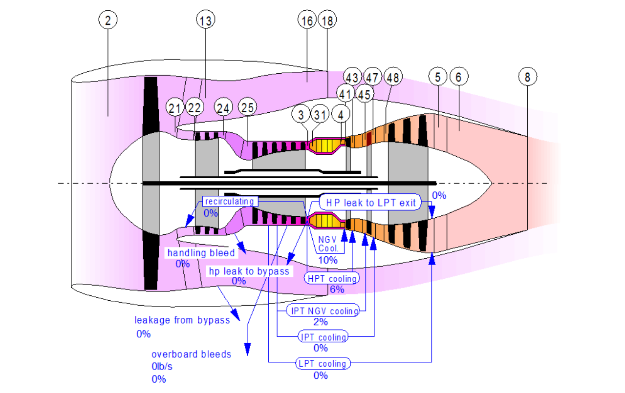
Figure 1. Principal picture of a three-shaft wide-body turbofan. Source: GasTurb.
Bjorn’s Corner: Aircraft engine maintenance, Part 6
By Bjorn Fehrm
April 7, 2017, ©. Leeham Co: Last week’s Corner developed the overhaul shop visits per year for wide-body engines. We will now look at how the market develops around these overhaul opportunities.
How does the shop structure develop over a popular engine’s life-cycle? How much choice has an operator and when?
Figure 1. Principal picture of a three-shaft wide-body turbofan with station numbers. Source: GasTurb.
Bjorn’s Corner: Aircraft engine maintenance, Part 5
By Bjorn Fehrm
March 31, 2017, ©. Leeham Co: In the last Corner, we showed flight hour graphs for wide-body engines. Now we will deduce the market for engine overhauls from these graphs.
It will show which engines are still in engine manufacturer care, in their main maintenance cycle and in the sun-set phase.
Figure 1. Principal picture of a three shaft turbofan. Source: GasTurb.
The phase the engine is in and its future flight hour development will decide the attractiveness of the engine for overhaul organizations. Read more
Bjorn’s Corner: Aircraft engine maintenance, Part 4
By Bjorn Fehrm
March 24, 2017, ©. Leeham Co: After covering the maintenance market for single-aisle engines, time has come for the engines used on wide-body aircraft. The engine maintenance for a wide-body engine is a bit different to the single-aisle engine. The difference is caused by the longer flight times for the wide-bodies. This makes the flight time wear a more dominant maintenance driver than it is for the single-aisle engines.
The changes in overhaul work caused by the difference in flight profiles and the lower number of engines in the market (compared to the single aisles) will affect how the overhaul market is structured and who are the dominant players.
Figure 1. Principal picture of a tri-shaft turbofan for the wide-body market. Source: GasTurb.
Bjorn’s Corner: Aircraft engine maintenance, Part 3
By Bjorn Fehrm
March 17, 2017, ©. Leeham Co: In the last Corner, we showed graphs of the yearly flight hours for engines on single-aisle aircraft. Now we will deduce the market for engine overhauls from these graphs.
These will show which engines generate a maintenance volume that is interesting for engine overhaul companies and which engines are niche.
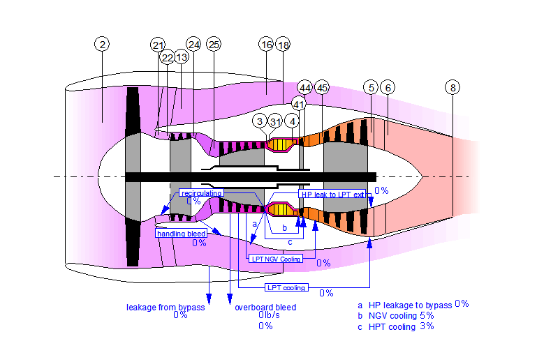
Figure 1. Principal picture of a direct drive turbofan. Source: GasTurb.
Based on the market size, we will then go through how an engine is maintained when new, mature and at end-of-life.